Australian company to start seismic survey off West Coast in January
Environmental report acknowledges that seismic blasts, which are much louder than gunshots, can kill fish particularly those with swim bladders
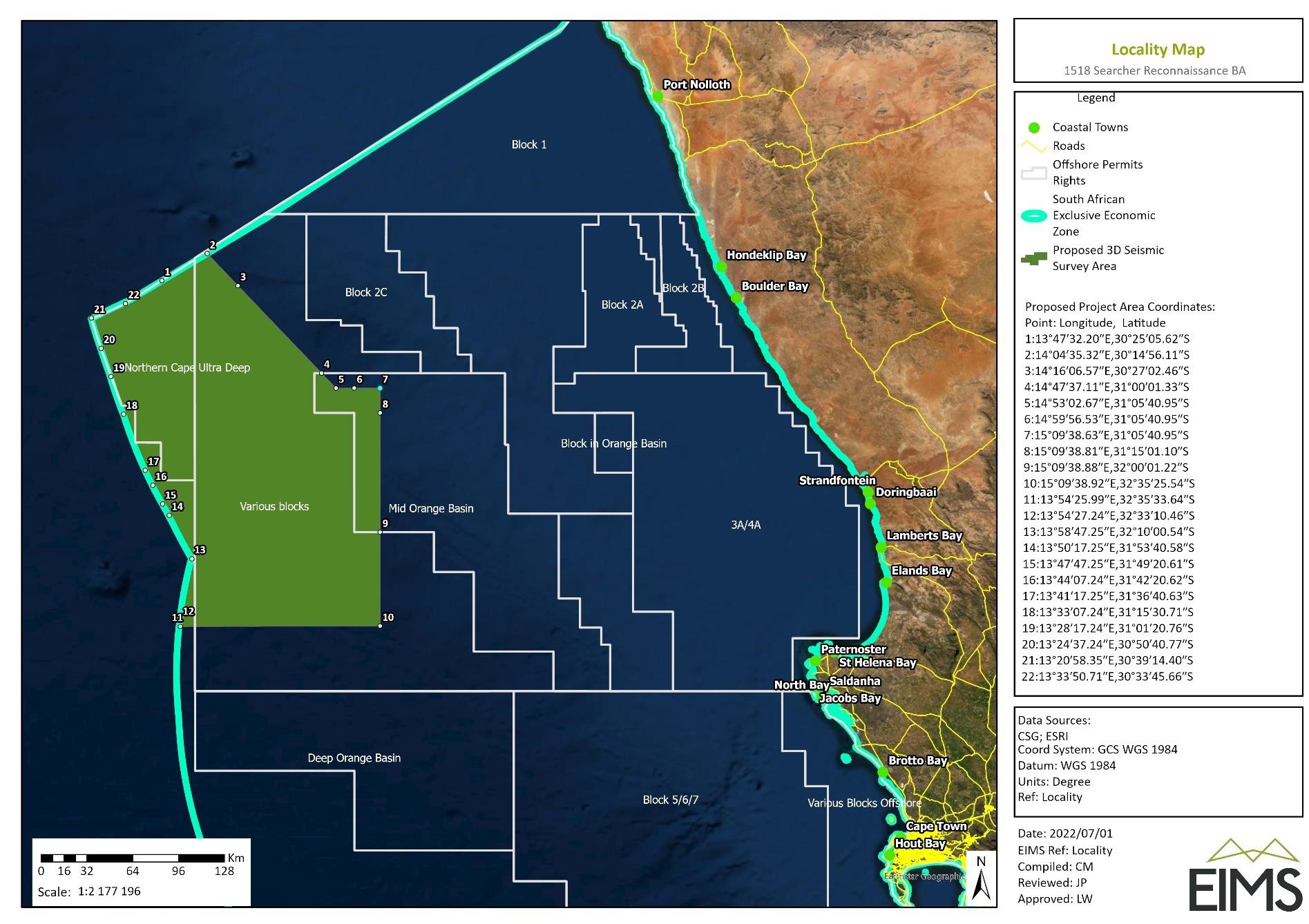
The green area is where Searcher Geodata will do its seismic survey in 2024. Map from consultant’s environmental assessment report
- Australian company Searcher Geodata is to start a seismic survey about 220km off South Africa’s West Coast in 2024.
- A previous application was halted in the Western Cape High Court in March last year.
- But after a new application was lodged, the Department of Minerals and Energy granted permission in December last year.
- The continuous seismic blasts are much louder than a gunshot, and the survey is expected to take 127 days to complete.
- The company’s environmental assessment acknowledges that the blasts can kill and injure fish, and small-scale fishers have expressed concern about the potential impact on catches.
At the start of the new year, an Australian company based in the UK, Searcher Geodata, plans to begin a seismic survey for oil and gas reserves off South Africa’s West Coast.
The survey, over 30,000 square kilometres about 220km offshore between St Helena Bay and Hondeklip Bay, involves blasting continuous pulses of sound at 255 decibels (dB) to create a 3D map of the seafloor and underlying geology. Decibel charts for human sound don’t usually go above 150dB, which is the intensity of fireworks and gunshots, and is considered painful and dangerous.
According to the Environmental Basic Assessment Report, sound levels will still be 160dB four kilometres away from the ship.
Searcher tried to start a 3D survey off the West Coast last year but was halted by an interdict obtained in March 2022 in the Western Cape High Court by small-scale fishers and civic rights organisation We Are South Africans.
Then on 20 December last year, the Department of Minerals and Energy granted environmental approval after a new application had been lodged on 1 November by a newly appointed environmental assessment practitioner (EAP), Environmental Impact Management Services.
On 1 December this year, Searcher sent an email notifying interested and affected parties that the survey vessel Ramform Atlas “shall commence 3D acquisition no earlier than 1st January 2024”.
The email said the survey blasting was expected to go on for 127 days, including possible downtime due to “operational delays or rough sea conditions”. Two support vessels are to accompany the Ramform Atlas, which will be towing an array of seismic receivers on 12 cables streaming 8.1km behind the ship.
The Basic Assessment Report required for environmental authorisation acknowledges that the seismic blasting can kill and injure fish, particularly those with swim bladders, such as hake, bigeye and yellowfin tuna. It can cause “behavioural disturbances” up to at least four kilometres away and “catch rates could therefore also be affected”.
“The spatial extent of the impact of seismic source noise emissions on catch rates is expected to be regional,” states the report.
But the report also says that only the large pelagic longline sector (mostly tuna fishing) “would be susceptible to impacts of elevated sound” and part of the mitigation is to conduct the survey within the first three months of the year which is “a period of relatively low fishing activity” for this sector.
Mitigation measures
Some measures are taken to reduce injury and death to fish, including giant squid which could be found in deep water in the area, and diving sperm whales. The Basic Assessment Report states the seismic blasting will begin with a “soft start”. This is believed to be a process in which the sound levels are slowly increased over 20 minutes to full volume, allowing species in the area to get away. Should an observer on the ship during the day spot any shoaling large pelagic fish within 500m of the ship, the seismic blasting will not start. However blasting may take place at night if there have been delays due to fog, for instance.
Seismic operations will stop if large pelagic fish such as whale sharks, basking sharks, and manta rays are observed within the 500m “mitigation zone”. Blasts will also stop if the observer on the ship sees “any obvious mass mortalities of fish” if it is “estimated” to be “as a direct result of the survey”.
The seismic vessel cannot alter its course easily, but daily notification of its course will be broadcast to fishing vessels and on maritime radio channels.
Small-scale fishers worried
The Heritage Impact Assessment (HIA) which forms part of the Basic Assessment, records the concerns of small-scale fishers voiced during public hearings. The HIA states that while scientific studies have found that the impact of seismic surveys on fishing stocks is low for all types of species, there is a potential impact on fishing yield which may impact small-scale traditional fishing communities.
“Communities have expressed definite concern about multiple applications in their fishing waters and potential long term effects of these surveys resulting in oil and gas companies applying for production rights.”
Exploration permits have been granted for about 98% of South Africa’s offshore Exclusive Economic Zone (EEZ).
“West Coast chief” Khaesen Maart is recorded as saying at a meeting in Saldanha Bay that the area of the seismic survey covers snoek breeding grounds. Small-scale fishers in Lamberts Bay are recorded as saying they believed there was evidence that seismic surveys conducted in 2021 affected their snoek catches in 2022.
This anecdotal evidence of the effect on catches for small-scale fishers was noted at a number of public hearings required for the environmental authorisation.
“These communities have expressed their concerns about the effect that the proposed 3D reconnaissance project will have on the fishing stock that will ultimately impact their livelihoods. It is also evident that they do not place much faith in the findings of the scientific fishing stock studies for this and other similar projects,” states the HIA.
But the Basic Assessment Report states small-scale fishers only operate to about 20km offshore and the impact on fishing stock is “low”.
Strategic Lead at environmental and sustainability organisation Green Connection, Liz McDaid, said the organisation had appealed to the Department of Forestry, Fisheries and the Environment (DFFE) after Searcher received their environmental authorisation, but the appeal had been dismissed.
McDaid said she believed seismic surveys were “very detrimental and damaging” to the marine environment. Green Connection intends to seek a legal opinion to determine whether it can apply for an interdict before the seismic survey began on 1 January.
She said for an interdict to be successful it would have to differ from the appeal to the DFFE and they were “considering prospects of success”. But “time is ticking”, she said.
Support independent journalism
Donate using Payfast
![]()
Don't miss out on the latest news
We respect your privacy, and promise we won't spam you.
Next: Workers under Creecy’s “cleaning and greening” project demand unpaid wages
Previous: The EU protects its companies from Big Pharma. South Africa needs to do the same
© 2023 GroundUp. This article is licensed under a Creative Commons Attribution-NoDerivatives 4.0 International License.
You may republish this article, so long as you credit the authors and GroundUp, and do not change the text. Please include a link back to the original article.
We put an invisible pixel in the article so that we can count traffic to republishers. All analytics tools are solely on our servers. We do not give our logs to any third party. Logs are deleted after two weeks. We do not use any IP address identifying information except to count regional traffic. We are solely interested in counting hits, not tracking users. If you republish, please do not delete the invisible pixel.